
Happy Monday! At 5:35PM, we’re monitoring two regimes of precipitation in Texas.
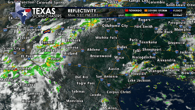
Evening radar shows scattered monsoonal storms across West Texas and New Mexico on June 23, 2025, with a severe storm warning near Roswell.
The first area of thunderstorms is moving north/northeast through the Texas Panhandle, West Texas, Permian Basin, Trans-Pecos, Davis Mountains, Big Bend, and the Borderland. More storms will move into the Borderland and Far West Texas overnight into Tuesday morning. A few storms this afternoon may produce damaging wind gusts. All storms will bring dangerous lightning, heavy rain, and possibly flash flooding.
The second regime involves ‘popcorn’ thunderstorms in the Rio Grande Plains, Deep South Texas, Southeast Texas, the Golden Triangle, and East Texas. A humid, summer-time environment has led to isolated thunderstorms. These storms produce brief heavy rain and lightning. They usually rain out within an hour and generate gusty winds that can spark new storms nearby. This activity will fade shortly after sunset.
You can stay updated by monitoring the sky with our free mobile app (just search for us where you download apps for your device). We also have interactive weather radar here on our website.