
Overview
A powerful cold front is moving through the Texas Panhandle today and will sweep across the entire state tonight. This system will bring thunderstorms, strong north winds, rapidly falling temperatures, and a widespread freeze for many areas by Sunday morning.
Severe Storm Potential This Afternoon and Evening
The Storm Prediction Center highlights the eastern third of Texas for isolated severe thunderstorms today. While widespread severe weather is not expected, a few storms may intensify.
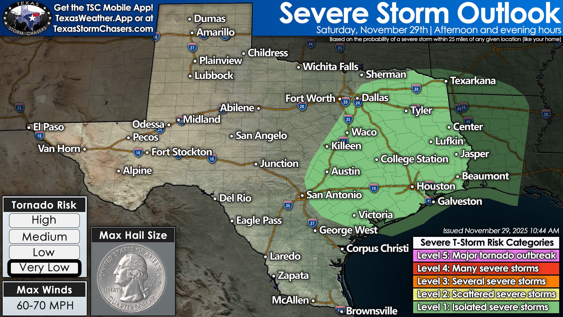
Low-end severe storm risk across portions of Central, East, and Southeast Texas on November 29, 2025.
Possible hazards include:
• Nickel-to-quarter-size hail
• Localized 50–60 mph wind gusts
• Heavy rain and street flooding
• A brief, isolated spin-up tornado
Areas with the highest risk include:
Brazos Valley, East Texas, Southeast Texas, the Coastal Plains, and the Golden Triangle.
Storms forming ahead of the cold front this afternoon and evening will need to be monitored closely.
Cold Front Timing and Dangerous Wind Gusts
The cold front will surge southward through the overnight hours. Once it arrives, temperatures will fall quickly and winds will increase sharply.
Wind gusts of 35–45 mph are expected across the northern 75 percent of Texas.
Expect:
• Blowing debris
• Difficult travel for high-profile vehicles
• Holiday decorations or outdoor items being displaced
The front is expected to reach the Rio Grande Valley by late Sunday morning.
Sunday Morning Freeze and Hard Freeze
By sunrise Sunday, much of the state will see its coldest temperatures so far this season.
Expected Lows Sunday Morning:
• Panhandle & West Texas: 15–25°F
• Northwest Texas, Big Country, Concho Valley: 20s to near 30°F
• North Texas, Hill Country, Northeast Texas: 30–32°F
• Central Texas: Low–mid 30s
• Southeast Texas: 40s
• South Texas: 40s to near 50°F before falling later in the day
A widespread freeze is likely across the northwestern half of Texas. Sensitive plants, outdoor plumbing, and pets should be protected.
Sunday & Monday: Cold Air Locked In
Sunday afternoon highs will remain well below normal:
• 30s: Panhandle and far West Texas
• 40s: Northwest Texas, North Texas, Big Country
• 50s: Central Texas & East Texas
• 50s–60s: Southeast Texas
• 70s: Far South Texas before the front arrives
Light rain returns Sunday night through Monday morning for the eastern half of the state. A few flurries may mix in across the Texas Panhandle, but no winter weather impacts are expected.
Next Week: Gradual Warm-up
• Tuesday–Wednesday: Dry statewide with slowly rising temperatures
• Thursday: A reinforcing cold front is possible
• Late Next Week: Another rain chance along the Texas Gulf Coast and eastern Texas
More details will become clear once the weekend system moves out.
How to Stay Updated
Stay ahead of changing conditions with Texas Storm Chasers’ real-time tools:
• Live 24/7 Weather Stream: Right here on our website!
• Interactive Radar: https://texasstormchasers.com/radar
• Free Mobile App: Search “Texas Storm Chasers”
• Website: https://texasstormchasers.com
We will provide updates throughout the weekend, including live coverage if tornado warnings are issued.